


When a Tree Falls in St. Louis, Will the Power Go Out?
Carrie Bebermeyer
Public Relations Director
carrie.bebermeyer@slu.edu
314-977-8015
Reserved for members of the media.
At SLU, geospatial science meets machine learning.
In a study recently published in Sensors, Saint Louis University researchers paired satellite imaging data with machine learning techniques to map local tree species and health. The data generated by the project will help inform best practices for managing healthy green spaces as well as trimming programs to avoid power outages following storms.
Vasit Sagan, Ph.D., associate professor of Earth and Atmospheric Sciences at Saint Louis University, says that managing healthy urban green spaces is a key strategy to combat global warming.
“With this work, our goal was to improve the quality of life in St. Louis and globally,”
Sagan said. “Trees and green spaces are critical in countering global warming effects.
In general, cities are around five degrees Celsius warmer than rural areas. To reduce
urban heat islands and climate change effects, we can increase green spaces.
“In this study, we mapped eight tree species: bald cypress, cottonwood, green ash,
silver maple, sugar maple, pin oak, Austrian pine and sycamore. Having a diversity
of tree species is great. On the other hand, some species are more susceptible to
storms as different tree species have different tolerance for stress. The overall
idea was to use space-based technology to identify tree species type and health condition.”
In the forest, a tree that is struck during a storm may just fall over without causing
much disruption. When a tree falls in St. Louis, it can cause a power outage. Understanding
the species and health condition of trees is important for safety and economic reasons.
Millions of dollars are spent on tree trimming each year.
“With data from this project, we can track the growth rates of different trees, which
can help agencies manage their trimming programs,” Sagan said. “This information
will be helpful for organizations like Ameren in their proactive tree trimming program.”
Sean Hartling, SLU graduate student and author on the paper, says that certain trees have greater vulnerability to stress and storms.
“Bradford pears or silver maples tend to be fast growing and cheap, so people like to put them in their yards,” Hartling said. “But, they’re problematic near power lines. Oak and walnut, on the other hand, are stronger trees.”
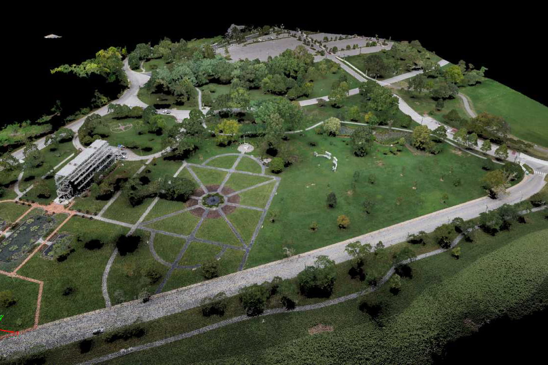
The researchers used airborne LiDAR (Light Detection and Ranging) system imaging together with satellite imaging techniques to gather data about trees. Then, they “trained” a machine-based analytic tool to identify trees based on that data.
“The whole point of this project was classification,” Hartling said. “By implementing a data fusion approach, we have data from different sensors which might pick up different nuances.
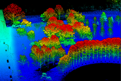
“LiDAR is high resolution and produces good imaging data sets. It gives us tree height
and structure. The visible near-infrared gives us information about the visual spectrum
characteristics, like the changing pigment between species. Short wave infrared gets
into the chemical properties, like water and chlorophyll content. We’re hoping this
data will help improve classification.”
“Then, we’re also examining deep learning, in which the classifier trains the machine
to identify trees. The ability to handle lots of training samples is a hot topic in
image classification. But, you still need samples to train the model.”
So, over the course of two months, Hartling digitized nearly 4,000 of Forest Park's 45,000 trees in order to “teach” a machine-based tool to use the imaging data to classify trees.
“We developed a geospatial analytics tool that fuses information from various sources to better discriminate tree type,” Sagan said. “This is really cutting-edge in the sense that on one hand we have really high sensory based data sets that can tell us the height, shape of trees, patterns, distributions. And we’re bringing that together with geospatial model tools using the latest deep (machine) learning. That’s the core of this research.”
The researchers’ next step will be to look at tree species, tree health data and utility information, overlaying the data and doing hotspot analysis, helping experts create maps of neighborhoods at risk of power outages during storms and helping to restore power quickly. As the team continues their work, they will add to their data sets using UAVs (Unmanned Aerial Vehicles), also known as drones.
“For the first study, we used satellite imagery,” Hartling said. “Next, we’re using small sensory UAVs for higher resolution and accuracy.
“We can cover about 80 acres on a 15 minute flight with a UAV. We can identify trees at risk of damage or disease. We might find browning at top of a canopy or a changing of the bark. We’ll see if we can find a method we can use on a larger scale.”
“We actually have LiDAR data for every single branch of the trees we studied,” Sagan said. “Now, we are using UAVs to go out and create our own data. The power of UAVs is that we can set up and test our own hypothesis, and then scale up to satellites.”
“Just like a doctor might use images to see if your lungs are healthy, we are using images to diagnose if a plant is healthy or not,” Sagan said.
The scientists have partnerships with several organizations in St. Louis. The current project mapped trees in Forest Park. Partnering with Bellefontaine Cemetery, the team is helping improve the environment and arboretum level in the Cemetery for rare plants and tree health by creating a 3D digital park, as well as mapping of invasive and rare plant species.
Other researchers on the study include Paheding Sidike, Maitiniyazi Maimaitijiang and Joshua Carron.
The research was funded by the National Science Foundation (NSF) (grant numbers IIA-1355406 and IIA-1430427 and the National Aeronautics and Space Administration (NASA) (grant number NNX15AK03H).
The paper’s digital object identifier is: https://doi.org/10.3390/s19061284
Founded in 1818, Saint Louis University is one of the nation’s oldest and most prestigious Catholic institutions. Rooted in Jesuit values and its pioneering history as the first university west of the Mississippi River, SLU offers nearly 13,000 students a rigorous, transformative education of the whole person. At the core of the University’s diverse community of scholars is SLU’s service-focused mission, which challenges and prepares students to make the world a better, more just place. For more information, visit slu.edu.